31/08/2016

The "Dutch SOTA" Tour - Day 1

In an attempt to activate all Dutch (PA/PA) summits, I made a three day tour along the summits I still needed. I had activated two of the five Dutch summits before.

On August 31st, I left my home at 05:45 local time, and after 300 km I was at the first summit.

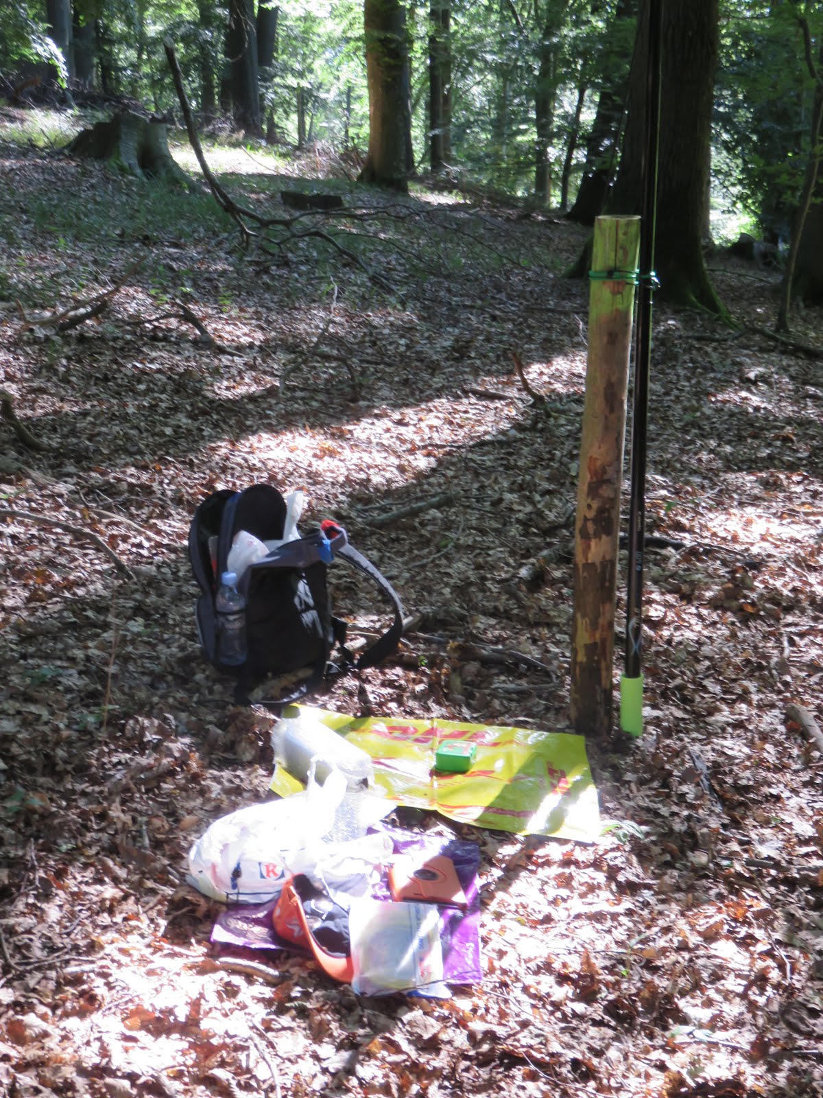
PA/PA-004 Torenberg, 107m, 1 point  [EDIT: this summit has been deleted]

I drove to position 52.232284, 5.862798 along the Amersfoortseweg near Apeldoornthere turned right onto Kampsteeg and parked at 52.231135, 5.865236. I found a nice spot with a little shade. I was QRV at 09:45 local time.


In less than one hour, I had 29 QSO's in the log, including 3 S2S.

Since it was not a big detour, I had a quick visit to the historic radio place Radio Kootwijk.


GPS position for driving is 52.174580, 5.827683, where you can park. Parking used to be free, but now it's 5 Euro for one day. You can't pay per hour.
[EDIT: there is free parking here 52.178435, 5.856207 (Hoog Buren, a 3.3 km walk)]

Info in Dutch about Radio Kootwijk is here

Since I didn't plan on visiting the buildings, I just took a few pictures and went to my second summit.


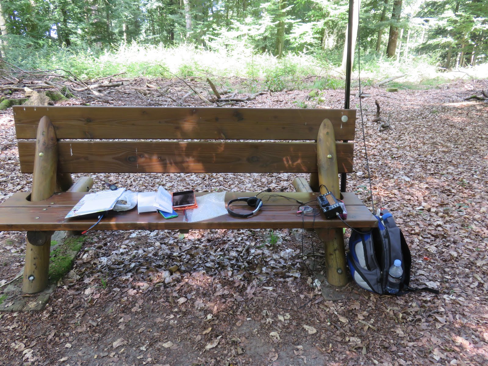
PA/PA-005 Galgenberg, 102m, 1 point [EDIT: this summit has been deleted]

Parking is here 52.059508, 5.939249.

This summit is only accessible by crossing the Terlet glider airfield and a camping site, so you have to ask permission. I tried to find someone to ask, but the place was deserted, it seems averyone had a coffee break at the same time. 
So I had no problem getting to the summit at position 52.063629, 5.932377.

A nice bench was half in the shade, so I could choose if I wanted to be sunburnt or not, hi.


I fixed my pole to the bench, and put up my link dipole. 
In just over one hour the bench was completely in the sun (hi), and my log showed 38 QSO's, including one DX with K4DY, and 2 S2S. One of the S2S was a bit special, as we will see later. It was with Hans PA0HRM/P, who happened to be close by on my next summit  ... over to

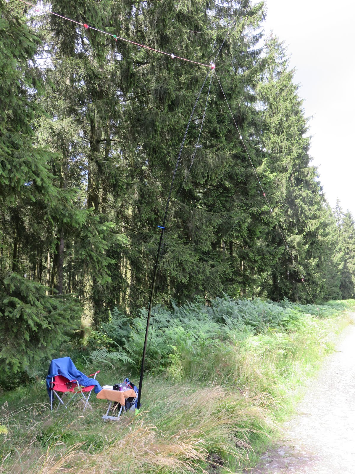
PA/PA-006, Signaal Imbosch, 110m, 1 point

Follow the Beekhuizenseweg to this parking place 52.037021, 5.990766, on Google Maps it's called "Parking De Brandtoren".
It is at the end of a cul de sac (called Signaal Imbos), it looks like a bike only path, but can be driven with a car, just look out for all the bikers.
Coming from the village of Rheden, it can be confusing to get there, at a certain point you have to take the narrow road to your left, across from a big parking lot. See screenshot from Google Streetview. You can even follow that small road with Streetview.

(Source : Google Maps)

Just when I had all my stuff ready to start walking, Hans PA0HRM showed up at that same parking, he had finished his activation. Great to meet the PA Association Manager in person !
I just regret that I forgot to take a picture ...

We had a short talk, and Hans gave me clear directions on how to find the exact location of the summit.
The summit marker is NOT where you see "Signaal Imbosch" on Google Maps !


So I started walking, first through this gate ... direction North-East.


After about 450m there is a forest track to your right.


Follow it some 200m, until the tracks widens and has some sandy open spots, there you have to go left and uphill and look for the summit marker, there is no fixed way to get there.
The summit marker is at position 52.03800, 5.99904
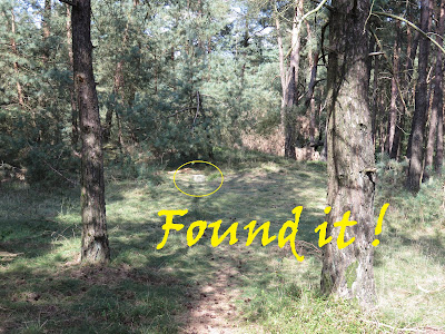


The marker stone made a nice place to sit on, and I used my small aluminium table for the KX3.
Perfect !


 It was already past 15:00 local time when I was QRV, and in another hour of playing radio, I had 26 QSO's in my log, and 2 of those were summit to summit contacts.
AND of course I couldn't be more pleased that Hans got home and worked me again, now from his home shack.

After that I had a 100 km driving to do, to the city of Venlo, where I had booked a room on AirBnb.

The story is continued on Day 2


09/08/2016

Ardennes and Luxemburg SOTA Tour - Day 4


For my trip back home, I had selected 4 easy summits.

First I went to

ON/ON-016 Les Aisances

I parked at pos 49.767429, 5.207851, and walked up the slope until I was in the AZ.

Some light rain didn't stop me from activating, I had an umbrella and rain coat, and to protect the KX3 and logbook, I used a large shopping bag on its' side, on my small table. That worked well enough to put 13 contacts in my logbook.


ON/ON-006 La Croix Scaille

This is also an easy drive-up summit, and even better, just across the French border is another one, so you can do two summits with little effort.
I parked my car a bit further than the official parking lot at the "Tour du Millénaire", where it was very busy. My parking spot was here : 49.954300, 4.844630.


I set up my station just across the road, but as it seemed, many walkers passed by, and of course I had to explain several times what I was doing. Also a car with two rangers stopped to check me out, but they were very friendly and made no objections.


The weather was a bit better here, so I could stay a bit longer, and made 22 QSO's.
After a quick lunch, I drove the forest road just across the border, to arrive on another summit ...

F/NO-047 Moulin de Thilay

Parking position was  49.948765, 4.841334, and I walked a bit further along the forest road to set up.


Also here, a car from the "Garde-Chasse" came by several times, they didn't even stop ...

But I got a funny question here.
Two people, a mother and her son had already given me some strange looks at the previous summit.

Now, by coïncidence, they had walked the same road, so they came by my station again, and this time their curiosity was too much and they asked what I was was doing , so I explained all about ham radio and SOTA.
Ah ... said the mother, I thought you were listening for the birds ...
I didn't tell her that we have indeed many "strange birds" in our ham community, hahaha.


I made 21 QSO's here, and also got 3 S2S !


After this activation, I drove back to the Belgian side, and quickly visited the Tour du Millenaire.
Read some info in English here.


A view from above on the parking lot, quite busy for a Tuesday afternoon ...


Now only one summit remained on my list ...

ON/ON-021 Plantis de Mesnil


If you drive slowly to this point, 50.177220, 4.916878, you will see where you can drive into the woods and find a parking spot for just 1 car (or maybe two if you're careful).
This is what it looks like in Google Streetview.


The parking spot is already in the AZ, but I walked a little on the path beyond the barrier to set up.
I didn't take any table or chair, so i just used some plastic bags as a "ground shack".


18 QSO's later, I packed all my stuff, and then it was time to take the long drive home ...
On the way home I saw a nice sunset, with some air balloons flying over ...


That's all folks ... a short but very enjoyable SOTA trip ... and 41 activator points added to my account ... nice.
See you all on the next trip !

Luc, ON7DQ

08/08/2016

Ardennes and Luxemburg SOTA Tour - Day 3


This day I activated the other 2 summits in Luxemburg.

LX/LX-004, Widderbierg - 387m, 2 points


I drove the Rue de la Grotte (in places also called Rue Wangert), from the village of Mensdorf.
Parking position was 49.65787, 6.31164, and from there I followed the track by G4OBK from SMP.
[EDIT : on later activations, I found a better parking spot and shorter walk into the AZ, see this report ]


I found a nice place to set up in the AZ, there was a pole in the ground that I could tie my fishing pole to.


Despite wearing long trousers and putting them in my socks, I got bitten by a tick on this summit, my first one in SOTA !
I found it on my belly, so it probably found its way "up" under my tshirt, while walking through the tall grass.

The activation resulted in 30 QSO's, and one S2S with Kurt, HB9AFI/P.


By the time I got back at the car, it was time for lunch .. my "baguette" was still fresh and tasty, keeping it in my cool box.
TIP : I bought it at Delitraiteur, Avenue de Longwy 400 in Arlon, pos 49.668036, 5.824249 , and it's only 2 km from highway E25. 


LX/LX-002, Grengenwald - 432m, 4 points


Second and last summit for this day.
I followed again the info and track from G4OBK.
Parking position 49.66892, 6.20344, and then track from SMP.
[EDIT : on later activations, I found a better parking spot and shorter walk into the AZ, see this report ]


After reading Phils' blog, I had to find the bench he wrote about, and so I did.
I tied my pole to the back of the bench and had a nice operating desk !

I made 18 QSO's, including 1 S2S.


And with that last one, I got all 4 summits in LX activated.

I still had most of the afternoon left, and so went swimming in Les Thermes in Strassen .. and of course I did fill up on gas before rerturning home the next day.


Continue reading on the trip back home on Day 4

07/08/2016

Ardennes and Luxemburg SOTA Tour - Day 2


This day I planned to activate 2of the 4 Luxemburg summits.
From my BnB in Arlon, it was only 60 km to the first one.

LX/LX-003, Kiirchbësch - 422m, 4 points


Parking position for this one was 49.891585, 6.224272 , which can be reached via a road called Am Roudebierg, starting in the village of Bettendorf.
I followed the instructions and track by G4OBK on the SMP site.


Since this was on a Sunday, and I had been told by Michael, DB7MM that there was a 2m contest in the morning, I had taken my FT857D backpack AND the KX3 set.
The VHF antenna was a 4 element logperiodic by Anjo Antennen, and for HF I took my simpler endfed with 9:1 UNUN, that I just made before this trip.
Lucky that the summit was only 10 minutes walk from the car !


 Above, you can see the UNUN fixed to a tree, and the other end of the endfed at some 6m above ground ,on  the fishing pole.

In one hour, I made only 5 QSO's on VHF, so again, not really worth to take the extra gear.
I continued on HF with the KX3 (which has an autotuner, the FT857D doesn't).
That went much better, in no time I had 14 more QSO's , including one S2S.

After a nice Lunch in Diekirch, it was time for the second one.


LX/LX-001, Steekammchen - 456m, 4 points


This is the parking position 49.97120, 5.95437
Again, Phil G4OBK had done all the work for me, so it was very easy to find a good operating spot, using the track from SMP..


The weather was nice, the views wonderful ... and I could fill my log with no less than 36 QSO's, with one S2S, all within one hour. All QSO's were made on 40m and 20m, using CW and SSB.

On the  return to my BnB in Arlon, I made a short visit to the dam in Esch-sur-Sûre ( pos 49.911780, 5.922893 ).


Continue reading on ... Day 3

06/08/2016

Ardennes and Luxemburg SOTA Tour

I  wanted to activate the four Luxemburg summits, and grab some more Belgian summits on the way, so I booked a nice AirBnb place in Arlon, and off I went ...

Equipment used on this trip : KX3 with a 12.6V/5800mAh LiPO
Power most of the time set at 10W, antenna was a homebrew link dipole for all bands from 40m up to 6m. Decathlon Lakeside travel pole 6m long, with simple ground spike.
Various small tables and chairs to choose from, depending on walking distance ...

August 6, 2016 - 4 ON/ON summits

ON/ON-017, Bois Haut - 405m, 4 points

I left Ostend at 05:45 local time, to my parking spot for this summit at 50.32272,  5.54484, where I arrived at 8:40 local, and 240 km of driving.
I came to this point via the village of Wéris, along the Rue du Broux.


The parking spot is in the AZ if you are in a hurry, but I walked 650m to the South-West, to find the trig point, which is at 50.318305, 5.536699.


The trig point is a large square block of concrete, so ideal to use as an operating table ;-)


With 49 qso's in the log, this was a good start of the tour !

ON/ON-019, Bois de Javingue - 365m, 2 points


I parked my car along the Allée des Moineaux, at this position 50.164948, 5.308194.
I couldn't drive any further like suggested by G4OBK, because everything was very muddy ... so I walked, until I picked up Phils' track as shown on the SMP.
The track goes South-West at first, and after a while it goes due West to the summit.
Somewhere along this last part, I found a nice spot to set up, which was well into the AZ.


On this one, I made 20 qso's, and had one S2S qso with Antonio EC2AG.


ON/ON-004, Bois de Hazeille - 586m, 6 points

Parking spot for this one is at pos 50.03334, 5.42859.
This is along a forest track in bad shape, that goes behind the radar towers on this summit.
It is a quiet place, but some military may come by on their patrol, so make sure to stay on the track and don't go into the forest !


I set up along the track and had a very good activation .... 42 QSO's in only 50 minutes, all on 40m and 20m, using SSB and CW.

Link Dipole (40-6m) on 6m pole


ON/ON-017, Bois Haut - 405m, 4 points


Last summit for this day, and also an easy drive up.
Parking spot is here 49.545825, 5.753395 , and this is in the AZ (you can check the place on Google Streetview).
There is a bench near the parking spot where you can operate, but I decided to walk 575m WEST to position 49.5436, 5.7461 , where the summit is.
I didn't find any trig point, so I'm not sure if there even is one.


Anyway, I did set up along the track, and  kept the activation a bit shorter, because I was getting behind on my schedule.
I made 19 QSO's in just over half an hour, and had one S2S.


After getting my favourite dinner at the Lunch Garden in Messancy ("Boulettes Liègoises and fries" , hi), it was time to find my BnB and have a good shower and some sleep ...


Continue reading on ... Day 2