24/09/2021

Cerro La Mola

EA5/AT-040, Cerro La Mola


I tricked my girlfriend into this last summit with the promise that there is a nice "Gaudi style" church on the summit ... well, kind of ...
This church and the ruins of a castle are next to the parking lot at position 38.409362, -0.794555
The church is called"Santuario de Santa María Magdalena" and the castle is  "Castillo de la Mola", see these websites for more info:
and


Now the SOTA summit is still more than an hour from the parking lot, it's a 1.2 km walk, with 185m ascent. This is the track we followed, it's the same as on the SMP by Thomas, DL8DBW.
The same advice as always ... if you do this walk on a hot day like we did, take enough water !


At first you pass an abandoned quarry, then have to find the start of the path, but it is very well indicated with white and orange stripes. The first part is a bit steep, later it gets flatter, and then the final climb is again a bit steeper. A walking stick is a good help at some points.

The quarry.


Start of the track.


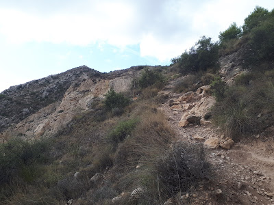
Final climb to the summit, but beware, the top in the middle of the picture is not the summit ... yet!
The summit is still another climb over the rigde to the right.


No radio towers at the summit, lots of space for antennas, and a n ice view of the church and castle, as you can see in the short video below the picture.


Luckily I brought my umbrella and wore a hat, so I could operate in the shade ;-)


This concludes the short EA5 trip of 2021. See you all on another one ...

73, Luc - ON7DQ

23/09/2021

Llorensa

EA5/AT-037, Llorensa

After a visit to Benidorm and Calpe, I had planned this easy drive-up summit. We approched it from the south, through a labyrinth of streets going through holiday homes of the "Urbanización Cumbre del Sol". As we got nearer, we entered a dense fog which also covered the summit. So far for the nice views ... and not much "sol" in the air !  Parking position was 38.719929, 0.159624


I quickly set up beside the road, and started my activation. It was not really cold, but there was a lot of wind and the air was very humid, so not a very pleasant stay.


Despite the circumstances, I was still happy with 25 QSO's in the log, and working ZL1TM as best DX made my day !


Here a few videos to give you an idea of the operating conditions ...


>>> Continue to the NEXT summit.


19/09/2021

Cocón de Cope

EA5/MU-162 Cocón de Cope

In 2020, I planned a nice three week trip to the Murcia - Valencia area with my new YL, but we had to cancel it due to Covid-19. This year, after we were both fully vaccinated, we decided to do a short version of this trip, limiting ourselves to the area between Murcia and Alicante. 
Finding some nice places to stay was a bit difficult, and in the end we ended up in three different spots (1-2-3 on the map below):
1. Aguilas on the 'Costa Calida' (the warm coast), 
2. Aiguës near Alicante, and finally 
3. Torre-Pacheco, which was very convenient because it is close to the Murcia-Corvera airport.

(click on the pictures to have a better view)


With only 12 days available (actually 10 days if you don't take into account the flights), I had to limit the SOTA activations to only three summits. But that was enough to get the EA5 Association on my list for the Mountain Explorer Award, and I even got a first activation of a summit. Nice !

ꙮꙮꙮꙮꙮ


The first summit was EA5/MU-162 Cocón de Cope. It is near Cabo de Cope and its' lookout tower, Torre de Cope. The nearest village is Calabardina. Parking position is 37.436556, -1.484821


The area is also known for its fossile dunes, very nice to have a short visit.


This is the track we walked, you can also find it in GPX format on the Sota Mapping site, or download it via SOTLAS. Note that this summit also has a trig point (vertice) which is valid for the Spanish DVGE program, but this  point is NOT in the activation zone for SOTA. 


Like most tracks, the beginning looks easy ...


Only after about two thirds along the way to the top, it began to get steeper and steeper. 


And the final part to the summit is just finding your own way, scrambling over the rocks ...
To my surprise, I saw that somebody was already on the summit. But when we approached, they were already descending, and getting closer, I could see the young girl of the couple was wearing nothing but a string bikini, and trainer shoes ... proper mountain attire , HI !


Finally reaching the summit, I could see that it had a lot of space for antennas, so I decided to put up my "long endfed".  Now, normally I carry two pieces of random wire in my backpack, one is 9.15m long, the other is 22m. To reduce the combined weight, I did some rethinking, and made an extension to the 9.15m wire (22 - 9.15 = 12.85m), so I had less wire to carry. The end result is the same.


Proof that my new system worked is the number of QSO's : 58 in total, including some DX, and 5 S2S contacts. This was also a FIRST activation for SOTA.
I was especially pleased to work friends Gary W0MNA and Martha W0ERI from the state of Kansas, USA !


Here a view from the summit to the West, showing the DVGE vertice (VGMU-018) on the lower summit, and the bay of Calabardina in the background.


>>> Continue to the NEXT summit.