Hello !
This is my day-to-day report of the 10 day trip to the Ham Radio fair in Friedrichshafen. I did the trip in three days, stayed 4 days in Friedrichshafen, and returned home in another 4 days. So I had plenty time to do some SOTA activations.
If you came to this page by accident and have no idea what SOTA is, read this page first What is SOTA?
If you came to this page by accident and have no idea what SOTA is, read this page first What is SOTA?

Today, I left my home town of Ostend at 05:27, had my breakfast along the road, and arrived at my first summit at 10:07. The temperature was already 25°C.
DM/NW-003, Ölberg - 461m, 4 points

Since this summit is in the Siebengebirge Nature Park , it is also valid for POTA, with reference DA-0046
Parking position 50.677540, 7.248780
Walking time 20 minutes one way.
Walking time 20 minutes one way.
This is a paid parking, I paid 2€ for 3 hours, which is sufficient for the walk to the summit and the activation.
The track is easy to follow, I uploaded it to the SOTA Mapping Site.

At the end you can take a shortcut using the "stairs" (right), but I just walked around, following the gravel road (left). I used the stairs in the descent though.

The restaurant at the summit was closed, and also the terrace was locked, and there was a warning about video surveillance.

To avoid any trouble, I returned and set up near the telecomms tower, just a bit below the summit.

Result : 29 QSO's with 5 S2S, no DX.

At 12:10 I was at my second summit, temperature 26°C and rising ...
DM/RP-366, Asberg - 441m, 2 points

Since this summit is in the Rhein-Westerwald Nature Park , it is also valid for POTA, with reference DA-0041
Parking position 50.618723, 7.308328
Walking time 30 minutes one way.
I followed the track by DL8DBW that is on the SMP site.
First I had my lunch, then started walking in the hot midday sun. The first part of the walk is a long and straight gravel road, rather boring, and there was no shade. I used my large umbrella for some protection, and when I entered the wooded area, it came in handy as a walking stick.
The track is not so difficult, although you must make sure not to miss some sharp bends.
Where the yellow circle is, it is easy to miss the narrow path into the woods, I did miss it at first ;-)
(see picture below the track).
(see picture below the track).
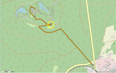

Last steps to the summit are a little steep ...

At the summit there is not much space, but I could easily set up my short random endfed (9.15m) as a sloper. I did not use the nice bench, it was in full sunshine. Instead I used the trig point stone as a seat, it was in the shade ...

Result : 34 QSO's with 10 S2S, no DX.
At 15:30 I was at the parking spot for my last summit. Temperature was now 29°C.
DM/RP-456, Dernbacher Kopf - 427m, 2 points

This summit is also in the Rhein-Westerwald Nature Park , and valid for POTA, with reference DA-0041
Parking position 50.540579, 7.571412
Walking time 5 minutes one way, no track needed.
Actually, there was no forbidden sign, I could easily have driven up to the activation zone.
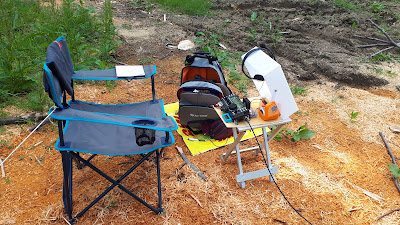
I did walk the short track to a nice operating spot beside the gravel road. Despite the heat, I dragged along a chair and a small table, so I had a nice outdoor shack!
Setup the antenna, connect to my all-in-one KX3 box and I was ready for some more SOTA fun.
Result : 23 QSO's with 3 S2S, no DX.

At 16:30 I left the summit, made a short stop at the Fashion Outlet Center in Montabaur (parking 50.443620, 7.832003), and arrived at my AirBnb in Weroth at 18:00, exactly as I had it planned, isn't that nice?
No comments:
Post a Comment
All reactions will be moderated. Publicity or links to other sites are not allowed.