29/06/2023

ON7DQ Friedrichshafen 2023 - Day 10

Going Home !

 This is the final day of my trip, not much to tell, only one familiar summit, and a long drive home.


ON/ON-016, Les Aisances - 445m, 4 Points


Parking: 49.759187, 5.212625
Walking time : none


I set up my station near the car and had a 1 hour activation.

Result: 29 QSO's with 13 S2S.


After that, all that remained was the drive home, where I arrived at 16:50 local time.

Tired but super satisfied with my trip !

I hope you enjoyed my report, and thet the info may be helpful for future activators.

73 and see you on the next one ... 

Luc ON7DQ


28/06/2023

ON7DQ Friedrichshafen 2023 - Day 9

Three summits in the Vosges region

I left my AirBnb in Riegel am Kaiserstuhl at 08:30, and headed for my first summit, an easy drive up.

FL/VO-019, Le Champ du Feu - 1098m, 10 points


Parking : 48.394729, 7.269334
Walking time : none

I set up my station a short distance from the car, which I parked on the side of the roundabout.

It was rather cool on the summit, only 13°C, so I had to keep my jacket on for the first time in 9 days.


Not  much to tell about this summit, it's an easy 10 pointer.

Result : 27 QSO's and 6 S2S, no DX but I was happy to work Tor-Atle LA9XGA far North on LA/FM-299 


The following two summits can be reached from the same parking spot, so that saves some driving time. I chose to activate the more difficult one first, and do it before having my lunch.


FL/VO-023, Le Donon - 1007m, 10 points


Parking : 48.515878, 7.170158, and it is not so easy to find.
There is only one forest road allowed to the parking spot, that road starts here 48.520756, 7.168198
, along the D145, a side road of the D993. See map below.

(source : Google Maps)

Walking time: 35 minutes ascent, along a difficult and rocky path, back down in 25 minutes.

The track is not really "exhausting", but it's very uneven and rocky, so you have to take care where you step, good shoes are necessary. Also take plenty of water on a hot day.

This is one of the turns you shouldn't miss, it also gives an idea of the state of the track.


And some of the rocks you have to climb over ...


These are the final steps to the summits ...


... and as always, the reward you get, is the view from the top


The few benches were all taken by visitors, so I found a spot at the shadow side of the temple, where I would not disturb the others too much.


Result: 20 QSO's and 5 S2S, no DX.


FL/VO-090, Le Petit Donon - 950m, 10 points


Parking : 48.515878, 7.170158, see info above under FL/VO-023, Le Donon, on how to get to the parking spot.
Walking time: 25 minutes one way, an easy walk. I followed the track by Phil, G4OBK, so I didn't upload another copy of the same.

Along the walk, you will notice a number of "Stèles" (memorial stone), these are stones marking the spot where both French and German soldiers from WW1 were found.


At the summit, there is a big rock you can climb ... I did!


And this is the real summit, but it is too small to set up a station with a wire antenna (a magnetic loop or small vertical on a tripod would be possible).


This is a view of nearby Le Donon, too bad one can not see the Temple on the sumit. 


Despite the cloudy air, it was getting quite hot, so I set up in the shadow of the big rock, and had a nice activation.


Result: 20 QSO's, including 3 S2S, no DX.


I was back at my car at 16:00 local time, and still had to drive 150 km to my last AirBnb, a nice 4 room apartment in Corny-sur-Moselle.
Including some shopping and a dinner, I finally arrived at the aprtment at 19:00.
End of another succesful day ... tomorrow is the last episode, the drive home, with only one summit.


Continue reading ... go to DAY 10 

or

Go back to overview HERE


27/06/2023

ON7DQ Friedrichshafen 2023 - Day 8

I took it easy on this day, only one summit but it was a nice one ...
My AirBnb was in Riegel am Kaiserstuhl, just 5 km from the parking for the summit.

DM/BW-115, Kaiserstuhl/Totenkopf - 564m, 4 points


At the SOTA booth in Friedrichshafen, Armin DL6GCA explained me the different possibilities to reach the summit, and where to park. There are two easy but long walks, and one which is short but steep.
Of course I had to choose that third one, I will probably never learn ...

Parking spot:  (Parkplatz Vogelsang)
Walking time: 45 minutes up, but I came down in 27 minutes, hi. Last 600m are quite steep.

The first part is a nice walk through this vineyard.


Then you arrive at this statue called the "Wanderer", which is German for "walker", not the English "wanderer" ... a bit confusing 


And here you have to look out, don't take any of the gravel roads, but find the narrow path that goes up between the bushes (see arrow on the picture below). On an OSM map, it's the path marked grade T1.


From there it is almost a straight line to the top, the last 600m are the steepest part.
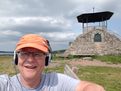
At the end you will see the Neunlindenturm, which  is a nice spot to set up, it is in the Activation Zone.


At the back of the tower, and in the shade,  is an old bench in a bad shape, so probably nobody uses it anymore, perfect to set up my station.
I did put up my QR code panel, just in case ...and two French girls that had climbed the tower came to scan them ;-)


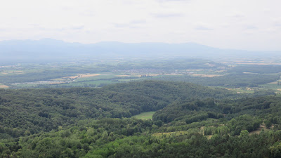
Since I was not in a hurry today, I took my time to climb the tower after my activation, and enjoy the nice views.


Results: 45 QSO's with 10 S2S. I had a good coverage of Europe, but again, no DX.


The rest of the day was spent with some shopping , and taking some rest, since the last two days of my trip would involve a lot of driving ... and more summits of course !

Continue reading ... go to DAY 9

or

Go back to overview HERE


26/06/2023

ON7DQ Friedrichshafen 2023 - Day 7

From Friedrichshafen to Freiburg 

As my first summit, I chose an old friend ... an easy drive-up

DM/BW-193, Schächer - 921m, 10 points


Parking spot: 47.888481, 8.577659 (near the TV tower)
Walking time : none, just set up on the picnic bench near the parking spot.


Result: 31 QSO's and 12 S2S, 1 DX (EA8 again ...)


DM/BW-014, Weisstannenhöhe - 1190m, 10 points


Since this summit is in the Südschwarzwald Nature Park , it is also valid for POTA, with reference  DA-0004.

Parking spot: 47.929588, 8.127853
Walking time: difficult to tell ... since I had to do the walk twice, or almost ... read on!
I guess a normal walk will take some 30 minutes, as suggested by the Google Maps route.

I had studied the track by Markus @HB9BRJ, so I didn’t expect any problems.
I parked my car at the “Wanderparkplatz”, in position ‘1’ on the map below, and first ate my lunch. 

Then I started walking and I wanted to go a little further than Markus, to the shelter near the summit, since that saved me from carrying a chair or table. So the intended track is seen below.


Just as I was at "point 1" on the above map, where I had to leave the gravel road and take a narrow and rocky forest track, a car came driving up the last part of the gravel road, honking like mad.
At first I thought they had some urgent business, and I stepped aside. But then the car halted, and a clearly excited lady asked if I was the owner of the car with the Belgian license plate.

Of course I was, and since I drove a brand new car, I thought “Oh no! Something happened to my car ?”

But no, the reason was something else. I had parked in front of some trees that were to be picked up that afternoon. The lady said “didn’t you see that you may not park there? It is clearly indicated in big letters on the trees!”.

Huh? I had not seen anything.

Anyway, the lady said “Get in, I’ll drive you down to the parking spot, to move your car”.
Now on that last part of gravel road it is impossible to turn a car, so she had to drive backward for a while until she could turn at point 2 on the map above. Then she drove at quite a dangerous speed to the parking lot. The car looked like a Citroen Berlingo (I forgot what brand it was), and had no airco, so I was sweating like hell.
While she was driving, she also got a phone call from her husband, who clearly was also nervous, and she shouted back at him “I found him, I found him!” ( in German of course).

At the parking, I looked for the sign she had talked about, and indeed , there were some crooked letters on the trees, painted with yellow paint, but the lady had to agree that the letters were hardly readable … Too bad I didn’t have the time to take a picture, since I needed to quickly move my car. It was OK to put it at position ‘2’ (on the first map above)).

But now comes the best part: the lady must have felt compassion for this old and sweaty man, carrying a heavy backpack … so she offered to drive me back to the point where she picked me up !
This is the first time I got a taxi ride to a summit (or at least part of the way). All in all, I may have lost only 15 minutes or so.

Being polite (as I always am, haha), I told her it was OK to drop me off at ‘point 2’ above, so that she could safely turn her car there.

After that, I reached the shelter without further interruptions and had a nice activation.


Result: 30 QSO's and 11 S2S, no DX


DM/BW-009, Kandel - 1241m, 10 points


This summit is also in the Südschwarzwald Nature Park , it is valid for POTA, with reference  DA-0004.

Parking position: 48.065336, 8.016146 , toilets available in a small separate building (to the left of above picture).
Walking time: 10 minutes, to a small lookout tower on the summit. There is a nice bench, but it's in the sun.


My setup:


At the parking spot, it was 'only' 21°C and it felt a bit cold, I think I was getting used to the 'near 30' temperatures ... so I was glad to have some sunshine at the summit ;-)


Result: 28 QSO's, that was nice, but I couldn't find any S2S station.  Finally, it was Michael DB7MM/P who came to the rescue! So 1 S2S , and no DX. Don't get fooled by the map, I think DJ9BX probably hasn't set his coordinates right ...


After that it was time to go looking for my AirBnb near the only summit I had planned for the next day : DM/BW-115, Kaiserstuhl/Totenkopf.

Continue reading ... go to DAY 8 


or

Go back to overview HERE


25/06/2023

ON7DQ Friedrichshafen 2023 - Day 6

I didn't buy a ticket for the Ham Radio today, instead I planned the activation of two nearby summits.

The first summit was my third attempt to activate it. At my first attempt in 2019, the summit was closed because of rockfall, last year I didn't make it because I was not feeling too well and it was very hot on the day that I was in the area, so I had to cancel again ... but this time it was going to work !

DM/BW-101, Hohentwiel - 690m, 6 Points

(source https://www.festungsruine-hohentwiel.de/en/)

Parking: 47.766977, 8.818272
Walking time: 25 minutes one way (but don't forget to reserve some time to visit the fortress !)
I arrived at the parking at 09:20, the temperature was already 25°C.

I had heard about this summit from Michael DB7MM in 2018, but never got the chance to visit.
To activate this summit, one must buy a ticket at the visitor centre near the parking, no tickets are sold at the fortress entrance (at the time of my visit, a ticket was 5€).

The walk up there is quite steep and it was rather exhausting on a hot day like this, take enough water!
But the walk is nice, don't forget to look around and enjoy.
You can also see the other "Hegau Volcano" summits of  Hohenwewen and Hohenstoffeln, I activated those in 2019.


Along the road is an old churchyard, then you walk through a tunnel, then arrive at an open space before the gate to the fortress. 


After that it's still some climbing before you finally arrive at the summit.


I walked around  some 30 minutes, then looked for a place to set up my station without bothering the other visitors, and found a nice spot at the far end of the fortress, near the "Pulverturm". 

(source: sotl.as)

There is nice picknick bench under a tree, almost hidden from view, can you spot it ?


I also set up the antenna so as not to block the passage.
I was well protected from the sun under my tree ;-), so it was a nice activation.

Result: 29 QSO's , including 10 S2S ! No DX.


At 12:00 I was back at my car, and first had my lunch.
Then it was time to find my second summit.

DM/BW-850, Hochbühl - 717m, 6 points


Parking: 47.803079, 9.139839
Walking time: 15 minutes one way

I had seen three tracks on the SMP site, but of course I chose the shortest one by Markus, HB9BRJ.
It's only 1 km and 15 minutes walking, to a spot which is in the Activation Zone. I didn't bother to walk to the real summit ... it was too hot, hi. Temperature was now 27°C, and by the end of my activation it was already 30°C !
And after all, at this spot you're only a mere 11 m below the summit.


I set up my station along the forest track, and I wasn't bothered by anyone ...
I used my longer wire again, and used the handle of my trolley backpack to raise the 9:1 UNUN about 1m above ground. 


Sitting on my mini aluminium table, used as a chair, I had a nice activation.


Result: 25 QSO's and 11 S2S, no DX.


I didn't make it too long, I was back at my apartment by 17:00. I had some packing to do and prepare the trip for the next day, direction Freiburg !

Continue reading ... go to DAY 7 

or

Go back to overview HERE